Marcin Stępniak
Marie Curie postdoc researcher
tGIS · Complutense University of Madrid
About me
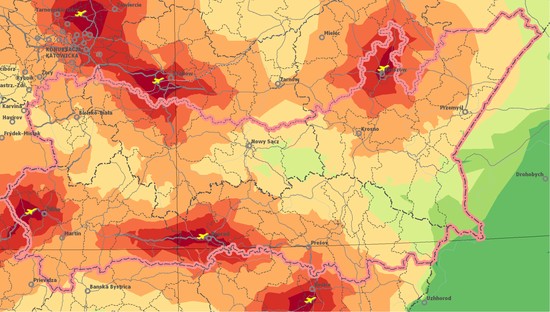
I am a transport and urban geographer. Currently I am a Marie Curie Postdoc Researcher working at the tGIS research group of the Complutense University of Madrid and researcher at the Institute of Geography and Spatial Organization, Polish Academy of Sciences. My research mostly focuses on accessibility in the urban realm extensively using GIS and R-scripting. Recently, I have been spending more and more time using GTFS feeds to visualize and analyse public transport networks.
On this webpage you can find a selection of my publications and research projects.
Interests
- transport & accessibility
- urban geography
- GIS & spatial analysis
- geographic data science
Education
-
Habilitation in Geography, 2018
Institute of Geography and Spatial Organization, Polish Academy of Sciences
-
PhD in Geography, 2011
Institute of Geography and Spatial Organization, Polish Academy of Sciences
-
European Master in Urban Comparative Studies, 2007
University of Urbino
-
MSc in Economic Geography, 2004
University of Warsaw